
We don’t ever want to be a flood prone province but the reality is we are !
Aug 12, 2025
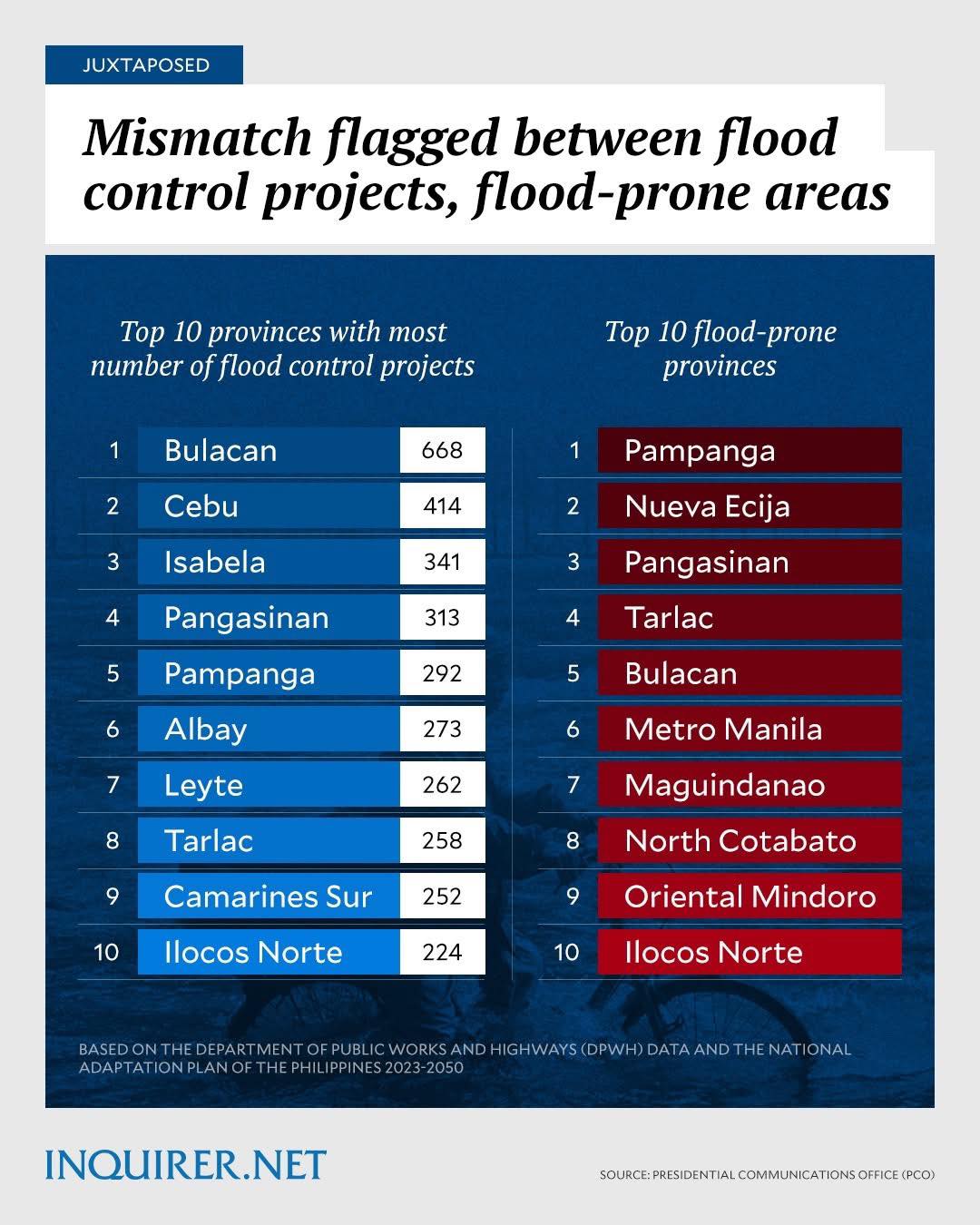
We appeal to the Climate Change Commission and the DENR, who prepared the 2023-2030 National Adaptation Plan, to verify, check, and validate their data and revisit their report, especially on the alleged list of the top 10 flood-prone provinces in the country.
![]() By geography, rainfall intensity, historical frequency, and flood duration, Camarines Sur is definitely flood-prone.
By geography, rainfall intensity, historical frequency, and flood duration, Camarines Sur is definitely flood-prone.
It’s not just about storm frequency but also the Bicol River Basin’s hydrology and low-lying topography that trap water, making CamSur highly vulnerable and flood-prone.
Aren’t geography and topography the main basis of the National Adaptation Plan in identifying the top flood-prone provinces?!
⸻⸻⸻⸻⸻⸻⸻⸻⸻⸻
 FACTS DON’T LIE:
CAMARINES SUR IS AMONG THE COUNTRY’S MOST FLOOD-PRONE PROVINCES. ![]()
In the history of flooding in the Philippines, Camarines Sur experienced the worst severe flooding in the past five years—triggered by Tropical Storm Kristine in October 2024.
![]() Intensity of Rainfall: An extraordinary 700 mm of rain in just 24 hours in Camarines Sur—equivalent to almost three months’ worth of rainfall—submerged vast parts of our province. Typhoon Ondoy had only 455 mm of rain in 24 hours but devastated Metro Manila. Imagine experiencing 700mm of rain in just 24 hours
Intensity of Rainfall: An extraordinary 700 mm of rain in just 24 hours in Camarines Sur—equivalent to almost three months’ worth of rainfall—submerged vast parts of our province. Typhoon Ondoy had only 455 mm of rain in 24 hours but devastated Metro Manila. Imagine experiencing 700mm of rain in just 24 hours
![]() Scale of Impact: The sheer magnitude of affected families reached record levels—hundreds of thousands displaced, thousands evacuated, and many lives lost.
Scale of Impact: The sheer magnitude of affected families reached record levels—hundreds of thousands displaced, thousands evacuated, and many lives lost.
![]() Agricultural & Housing Damage: Crops destroyed, homes washed away, communities devastated.
Agricultural & Housing Damage: Crops destroyed, homes washed away, communities devastated.
![]() Prolonged Flood Duration: In the most affected areas, floodwaters took up to 3 weeks to fully recede.
Prolonged Flood Duration: In the most affected areas, floodwaters took up to 3 weeks to fully recede.
And yet, despite this undeniable reality, Camarines Sur was NOT included in the so-called “Top 10 Flood-Prone Provinces” identified in the National Adaptation Plan 2023–2030.
⸻⸻⸻⸻⸻⸻⸻⸻⸻⸻
 Let’s be clear:
Camarines Sur is a catch basin and the low-lying heart of the Bicol River Basin. By nature, we bear the brunt of heavy rains, typhoons, and river overflows. Our experience in 2024 and past flooding—backed by actual rainfall data, evacuation records, and damage assessments—proves beyond doubt that Camarines Sur must be recognized as one of the most flood-prone provinces in the country. We experience flooding not even during typhoons because we are a catch basin. Camsur province is also in the typhoon belt and path.
This isn’t about titles or lists—it’s about accuracy, preparedness, and prioritization. When national policies fail to reflect ground realities, communities remain at risk. We will continue to appeal and push for proper recognition and inclusion so that Camarinenses hopefully receive the proper attention, funding, and protection we deserve. ![]()
![]()
![]()
![]() What do you think—is Camarines Sur among the top flood-prone provinces in the country?
What do you think—is Camarines Sur among the top flood-prone provinces in the country?
⸻⸻⸻⸻⸻⸻⸻⸻⸻⸻
Just as a recap:
Major Typhoons & Flooding Events in Camarines Sur
- Tropical Storm Trami—Locally: Kristine (October 2024)
- Brought unprecedented rainfall and forced mass evacuations in Camarines Sur, turning roads into fast-flowing rivers, especially in low-lying areas like Milaor, Minalabac, Nabua, Naga, Pili, Baao, Gainza, and Camaligan.
- Declared as the worst severe flooding in the Philippines over the past five years due to its intensity, duration, and devastating impacts.
- Extraordinary 700 mm of rainfall in 24 hours in Naga City; floodwaters in some areas took up to 3 weeks to fully recede.
- Typhoon Ulysses—International Name: Vamco (November 2020)
- Triggered widespread flooding across 235 barangays in Camarines Sur, affecting ~52,021 individuals (12,935 families) and prompting large-scale evacuations.
- Overflowing of the Bicol River and Ombao River inundated towns such as Baao, Bula, Pili, Minalabac, Milaor, San Fernando, Naga City, Bombon, Magarao, Canaman, Gainza, Pamplona, and Calabanga.
- Resulted in 1 confirmed fatality in Camarines Sur and billions of pesos in damages to agriculture, infrastructure, and homes.
- The impact was compounded by preceding typhoons (Rolly and Quinta), which had already saturated the ground.
- Typhoon Yagi (November 2023)
- Coupled with the southwest monsoon, Yagi caused significant flooding in Metro Manila and extended to provinces including Camarines Sur, resulting in 21 deaths and multiple injuries.
- Typhoon Kammuri—Locally: Tisoy (December 2019)
- Kammuri’s eyewall and heavy rains created widespread flooding and infrastructure damage in Camarines Sur (and the wider Bicol Region).
- Declared a state of calamity due to flooding and school damages—around 293 classrooms affected in CamSur alone.
- Typhoon Kujira (May 2009)
- Affected Region V, including Camarines Sur, causing around 28 deaths, over 2,300 houses damaged, and substantial economic losses.
- Prompted a state of calamity in the province.
- Typhoon Nina (1987)
- One of the most devastating historical storms: in Camarines Sur alone, 32 people were killed due to flooding and landslides, with catastrophic destruction of homes and farms.
Other News
ADVISORY: PRE-EMPTIVE EVACUATION 📢
Sep 24, 2025RED ALERT Status raised in Camarines Sur due to Tr...
Sep 23, 2025Malacañang Suspends Work in Gov’t Offices on Sept....
Sep 21, 2025🌟 BIG NEWS for CamSur! 🌟
Sep 18, 2025Wheelchair Assistance Delivered to Residents of Mi...
Sep 16, 2025